About
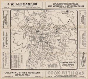
This selection of maps illustrates the development of Spartanburg County from an isolated settlement to a regional center as few other historical resources can. In addition to documenting areas rarely photographed, maps can be useful to researchers interested in charting the changes in land use for a given geographic area. Information included in many of the maps includes streets, rivers, railroads, landmarks, and major landowners. To see these and other maps of the region, please visit the Kennedy Room in the Headquarters library of the Spartanburg County Public Libraries.
Related Terms:
- Spartanburg County Public Libraries
Institution:
- Maps
Media Types:
- Spartanburg County