About
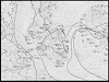
This series of 31 maps of the South Carolina coastline depicts water-surface elevations, high water marks, and landward extent of storm-tide inundation caused by Hurricane Hugo, September 21-22, 1989.
This series of 31 maps of the South Carolina coastline depicts water-surface elevations, high water marks, and landward extent of storm-tide inundation caused by Hurricane Hugo, September 21-22, 1989.